Introduction
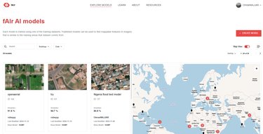
fAIr (f for freedom and free and open-source software, AI for Artificial Intelligence, r for resilience and responsibility) is an open-source AI-assisted mapping tool developed by the Humanitarian OpenStreetMap Team (HOT). Working on satellite or drone images, it supports local community mappers to identify and mark humanitarian features such as buildings and roads which are then added to OpenStreetMap (OSM) to be freely available to anyone who needs the information.
Background
When disaster strikes, mapping the impacted areas to a high level of detail helps humanitarian responders assess impact and make plans to support communities in need. Making this data available for free is one aim of the OSM project, which works with locally based mappers in communities across the world to collect geographic data. To support these mappers, the HOT team has developed a range of open-source tools to support the collection of data and use it for decision making.
But the detailed mapping of buildings and other features is tedious work for humans. Research conducted by the HOT team, together with the Netherlands Red Cross 510 Team, has shown that mappers can, on average, map between 1000-1500 buildings per working day. When they tested AI-assisted mapping, it was found that this number nearly doubled. This represents a great opportunity to speed up the mapping process.

However, to enable an AI model to provide assistance to human mappers, training data is needed that reflects the environment that mappers are working in. Crucially, most of the existing data that could teach an AI to identify features such as buildings has been created in the Global North and is not representative of the local contexts that HOT’s mappers operate in. The HOT team had to find an approach where local communities could mitigate biases and create local context data to train the AI first, and then use it to assist with their mapping efforts.
AI development
The HOT team knew from their research that the AI assistant process could amplify the human efforts of mapping. For the mapping data to be good quality, the AI assistant needed to be trained with relevant, local data sets collected by community members, who would also always be in the loop to confirm the correctness of the mapping and provide feedback. It was also important for the solution to be truly open source and transparent regarding the data used. Finally, capacity building was important – community members should be able to use the tool easily, without the need for a data analyst or machine learning engineer.
The team conducted extensive research and experimented with different approaches and AI models. In collaboration with Omdena, they ran an AI Innovation Challenge for a diverse group of 50 AI specialists from across the world. They learned that small, local datasets actually increased the accuracy of the models. This means the local AI models predict better buildings and roads than a global model. At the end of that process, they decided that the Replicable AI for Microplanning (ramp) model was the best choice for fAIr.
User acceptance testing for fAIr was conducted by teams across the four Global South Open Mapping Hubs, in Nepal, Liberia & Sierra Leone, Takuma Camp in Kenya, and Dominica. Up to one hundred mappers successfully tested AI assisted mapping of buildings based on aerial imagery. On 31 May 2024, the solution was made available for use by the wider OSM community.

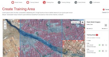
The concept of fAIr is simple. A community mapper creates an initial training dataset by manually mapping features from imagery for a small area. Then, this dataset is used to train the AI; following that, the AI can rapidly create mapping suggestions across a much larger geographical area. Importantly, the user must validate and accept or discard any features that have been mapped by the AI, and that feedback is used to further train and improve the AI model.
Operationalising AI
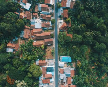
fAIr is tested to support 100 concurrent mappers mapping in HOTOSM hubs. Learning materials and demonstration videos are available to anyone who wants to use the solution. A larger scale-out will be dependent on the availability of geographic imagery. And this is one of the challenges; commercial providers charge a fee for fAIr to access their images, so the focus is on using open-source aerial imagery which is not available for all geographic areas. As an alternative, fAIr is also testing the use of drone images taken by local mappers.
The team continues to work closely with the current users to constantly improve the quality of fAIr’s mapping and address their concerns about using the AI assistant in the first place. They ensure that the inner workings of the AI are understood and emphasise that the tool is only an assistant, while the human remains in charge of the mapping process.
Learnings
It was important to fAIr to have scientific proof for the team’s assumptions about the benefits of AI-assisted mapping. Working with Masaryk University, Czech Republic, they created 25 different AI models and conducted “mapathons” to measure the difference between manual and AI-assisted mapping. Geographical areas were classified as "easy”, “middle”, or “hard”. Unsurprisingly, AI assisted mapping showed to be most effective and efficient in “easy” areas – where buildings could be recognised as such relatively easily and were not stacked or within an informal settlement. This is a challenge even for human eyes – and it means that particularly for such “hard” areas, community members on the ground need to review and correct the initial AI mapping to achieve a good quality of mapping.
The team also learned the importance of having a good user interface for fAIr. This was not an initialy area of focus and, in hindsight, is something they would do differently now. For the current version 2.0 of fAIr, User Interface/User Experience (UI/UX) specialists made changes based on initial user feedback to make fAIr a lot more user friendly with fewer technical terms.
Plans for the future
Continuing to collect user feedback and making improvements is also part of fAIr’s 2025 roadmap. Plans also include two more projects in Latin America and Asia, where the local communities will create drone imagery to use for mapping.
The fAIr team also wants to add further features to be identified by AI, such as road types and building materials, and is conducting research on which AI models they might use for this. And finally, the team is looking to integrate fAIr with other applications in the wider open street map ecosystem, to create increasingly complete and detailed maps across the world.
Where to learn more
- Omran Najjar, Senior Technical Product Owner - AI, omran.najjar@hotosm.org
- https://fair.hotosm.org/
